@mercury1123 ,
Excellent question. The Honeybee microclimate maps and Ladybug Solar Temperature Adjustor are using the SolarCal model.
The Fsvv is computed by shooting out a hemisphere of rays from the point of interest (where the occupant is located) and seeing how many rays get through geometry to see the sky. This is the case for both the microclimate maps and the solar temperature adjustor.
For the Fbes, the sun vector for the given hour is shot through the point(s) of interest to see if the occupant’s body sees the sun and experiences the effect of direct sun. I say point(s) because the number of points used varies depending upon whether you are using the microclimate maps or the solar temperature adjustor. Since the microclimate maps are concerned about comfort at series of individual points in space, only a single point is used and so the Fbes can only be a 0 or a 1. For the solar temperature adjustor, at least 3 points are used (feet, mid-section and head) and as much as 9 may be used. This results in something that can be a true fraction of the body rather than a 0 or a 1.
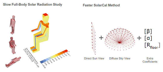
Altogether, I typically explain the solarcal model to people using the following graphic:
Whereas, historically, we had to do an entire solar radiation study of human geometry to estimate the MRT delta from the sun, the SolarCal model simplifies this by only tracing a few vectors from points of interest and using coefficients to account for how the sun falls onto the human geometry.
