Hi everyone,
I have started looking into Dragonfly and in particular the UWG
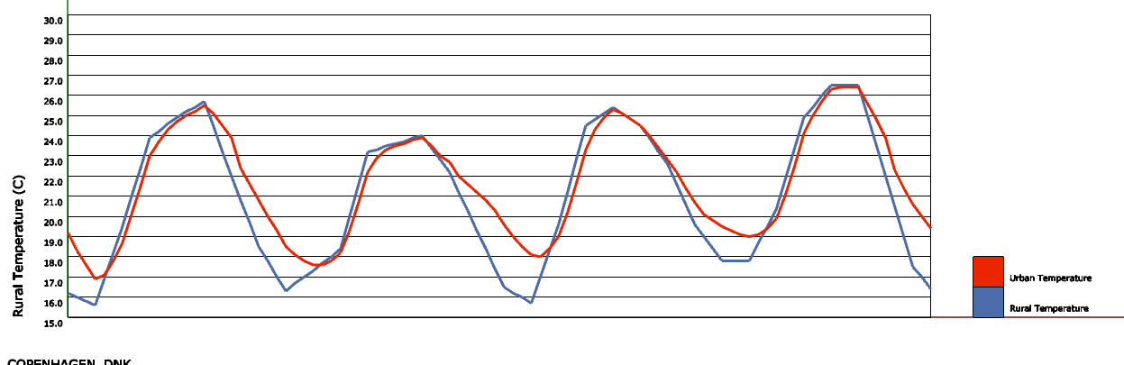
I am currently trying to check the sensitivity of the solver with respect to the different parameters using Copenhagen as a reference, mainly because I live there
During one of the tests I tried to set a rural condition for the City definition with 99% of the site covered in grass:
City:
Average Bldg Height: 8 m
Site Coverage Ratio: 0.01
Facade-to-Site Ratio: 0.1
Tree Coverage Ratio: 0.0
Grass Coverage Ratio: 0.99
Building Typologies:
0.1 - LargeOffice,NewConstruction
0.9 - MidRiseApartment,NewConstruction
I have used the following settings for traffic, vegetation and pavement:
I would expect the two curves to be very similar, in particular considering that the default assumption for the rural EPW should be a grass coverage of 90%
Am I missing something obvious?
Has anyone experienced a similar trend?
@SaeranVasanthakumar might be able to answer some of these questions better than I can since he did the translation of the UWG to Python.
However, to take a stab here, it seems like your case is not described well by the underlying assumption used by the UWG, which is that it models a generic “infinite street canyon” with the input building height and it uses the other two geometry parameters to derive the width of this canyon along with the other heat exchange parameters. If your site consists of a single tower that only overs 1% of the site, the “infinite canyon” assumption doesn’t seem like the right way to estimate its effect on the surrounding air temperature (if any).
It might be a good idea to read some of the original research on the UWG, such as Bruno Bueno’s PhD thesis, where he developed the original version of the UWG so that you can assess whether the UWG is the right tool for the question you are asking.
I think the differences can be explained by the underlying assumption of a infinite canyon that @chris refers to.
Check this post Urban Heat Island in an “all-green” scenario for a similar attempt by another user at modeling a rural scenario. Relative to your scenario, he had some additional complexity with trees, which don’t apply to you, but you can see my explanation of some of the macro-parameters that assume urban conditions. You can modify them to get your UHI to a more reasonable level, but fundamentally, the UWG isn’t meant to model this type of pure rural condition with no built canyon.
I will try to play a bit with the boundary layer and site parameter to get a better fit and have a look at the PhD thesis as well
My hope was to take a large chunk of city, say NY, divide in tiles (for example 250mx250m) and use the UWG on each tile
I would then use a 2d interpolation method to obtain local values of DBT and RH on a target mesh
A present however the effect of say Central Part compared to a typical urban tile is minimal (1°C max)
I can see noticeable effects on DBT only on really dense tiles (build up > 60-70%) with substantial avg. building height (> 30-40m)
Seems a bit too extreme in my opinion
Maybe tweaking the parameters will help getting a smother and more gradual response
Hi @SC05 , did you make any progress with the tile subdivision methodology for NY? I would be really curious (and grateful) to hear about your findings