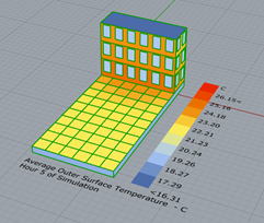
For my MSc thesis, I’m interested in looking at the effect of MRT due to longwave radiation only. I’m considering two different methods for getting the longwave MRT only. For both methods, I’m considering the model below. In this particular situation I’m looking at the longwave MRT at 04.00 at night (so no sun, and thus no shortwave irradiance). At 04.00, the surfaces have the following temperatures:
Method 1: Using the Ladybug_MRT calculator to calculate longwave MRT
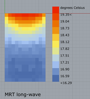
For this method I’m using the Ladybug_MRT calculator as used in this example for the calculation of the longwave MRT only. Upon calculation I get the following result for 04.00 at night:
Method 2: Using the Microclimate map to calculate longwave MRT
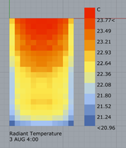
For the second method, I’ve used the Microclimate map method to obtain the MRT values. Since I’m looking at a night-time situation, there’s no shortwave irradiance. Therefore, the MRT as obtained from the microclimate map is the longwave MRT:
Now my question is: What causes the difference between these two results? And which result is correct? To me, the result above seems more sensible, as it compares better to the distribution of surface temperatures.
Now, my second question is:
In case the Microclimate Map gives a more accurate representation of the MRT. Is there a way to separate the longwave radiation from the shortwave radiation in the output? From the component I can only get the radTempMtx, which gives the sum of the shortwave and longwave MRT. I’ve had a look at the code inside the component, however, since I’m not very experienced with Python I do not know how to separate these two and change the output. Any help on this would be greatly appreciated!
Thanks in advance for having a look at my questions!
In your first example (using the “Ladybug_MRT calculator”) the script you’re referencing is a “deconstructed” microclimate method. As described by the Hydra description, that script breaks down the calculations done by the Honeybee Microclimate component explicitly, but otherwise should be equivalent.
It looks like there’s a lot of minor differences in the setup of the scripts which could be causing the difference in your outputs, including view factor grid resolution, the EnergyPlus simulation timestep, and analysis interval. Are you sure these are all equivalent?
Actually I missed the more obvious problem, which is that the file you’re linking to is an indoor microclimate analysis. Have you modified the script for outdoor use, and if so how?
@SaeranVasanthakumar Thanks a lot for your quick response. Unfortunately I forgot to include the script with my last post. I’ve added it to this post now!
The deconstructed microclimate method as shown in the Hydra example indeed refers to an indoor microclimate analysis. I’ve accounted for this by calculating the sky view factor and long-wave sky temperature (which is calculated as shown in this paper). And adding it to the longwave MRT calculation with the “Ladybug_MRT calculator”.
Since both methods use the same EnergyPlus calculation to calculate surface temperatures, I think this is not the problem. I think that the problem is more likely to be linked to the way the view factors are calculated, since for the first method I’m using the "Ladybug Surface View Analysis"and for the second method I’m using the “Honeybee Indoor View Calculator” (altered for outdoor use).
Something that I might try to get more similar results between the two methods:
Also use the “Honeybee Indoor View Calculator” for the first method, however I do not know how to access the actual view factors from the ViewFactorInfo output. Is it possible to do this? (This is the same questions as was asked here)
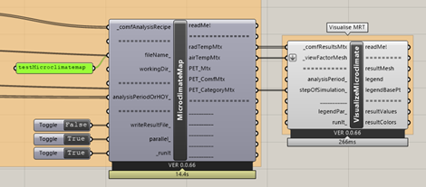
Finally: I’m still wondering whether it is possible to get the longwave-MRT values from the Python script in the MicroclimateMap component. Do you have any tips on how to do this?
The script helps a lot. There’s a lot of complexity there, and I wasn’t able to run it, so I can’t say I was able to vet everything, but in general your strategy for using the ladybug MRT component looks correct to me (including the sky temperature calculation and sky view factors). The microclimate map component also looks right, but it’s kind of blackbox component so who can really tell.
You might have an error with your timestep selection for the Tsky component. You are subtracting the time step of simulation by 1 to get the Tsky value at that time step. But since the stepOfSimulation slider starts at 0 like the input infrared radiation data, they should already be consistent.
Also, is there a reason you’re using Legacy and not the [+] components for this anaylsis?
Re: getting custom outputs by hacking the MicroclimateMap.
At some point I spent some time to doing this with the MicroclimateMap, but it wasn’t trivial. I think moving over to the [+] (if possible) will be the better solution.
Thanks a lot for having a look at my script. The reason why I’m not using the Ladybug Tools Microclimate Map yet is because I’ve read here and here that the new microclimate maps simplify the longwave MRT calculation by not taking into account surrounding surface temperatures for the calculation, but rather use MRT for a person standing in an open field.
So, why I asked this question in the first place is because I’m interested in combining the longwave calculation method as used in Legacy with a shortwave calculation method using Radiance in Ladybug Tools. I’m planning to use the “Ladybug_MRT calculator” to calculate longwave MRT and then using either the shortwave_from_horiz_components or shortwave_from_horiz_solar formula from the SDK. As solar irradiance input, I’m using the results from a Radiance (LBT annual radiation component) study. (See also my conversation with @chris on this topic.)
The following script: MRT comparison Radiance methods.gh (752.8 KB) shows the workflow for both the shortwave_from_horiz_components method and the shortwave_from_horiz_solar method. Would you think this method of combining longwave MRT and shortwave MRT is reasonable? And if so, would you know what could explain the difference between the two methods (shortwave_from_horiz_components and shortwave_from_horiz_solar), and which one is more likely to be correct? (If I change the floor reflectance for the first method, you barely see any differences, however if the floor reflectance is changed for the second method, quite large differences are seen).
@n.dewaard I think your proposed workflow makes sense from a radiation balance perspective. However, I am not that familiar with all the specificities of accounting for human geometry/material in microclimate analysis, so I could be missing something in that domain.
Those differences make sense to me. The first method (..._horiz_components) incorporates the reflected ground global radiation from Radiance (from the downward-pointing sensor grid), while the second method (..._horiz_solar) approximates that value from parameters, which notably doesn’t have an input for sky exposure, (and so assumed to be 1). The obstructed sky must therefore be reducing your output’s sensitivity to ground reflectance in the former method. So the ..._horiz_components method is the one that is more correct.