My problem is being able to understand with which criterion it is calculated, find the minimum solar elevation of other cities (not in the list) and bring it into Ladybug.
Normally, the lowest maximum altitude of the sun would be at noon at winter solstice (21 December) at 66.56° (90° minus the ecliptic angle of 23.44°), minus the latitude of the desired location, but with this procedure, I don’t get to have the values in the table.
I also tried to calculate the sun elevation angle at noon on 21 December, minus the latitude and compared with the cities on the list, in many cases, the γs,min was equivalent, in others not.
I really hope in some help, to resolve this doubt, from some expert of the subject.
I think among the people on the forum @ChristianKongsgaard might be the one who could help with this question. Isn’t it something that should be documented in the building code? They can’t just assume the study will be only executed on those cities.
Hallo @mostapha,
thanks for tagging who could help me, I hope you answer me!!
… the code says: “Further cities could be added to the countries to more precisely determine the influence of latitude and climate”
Unfortunately the standard describes how it is possible to calculate the position of the sun in the sky, also the solar elevation, but not the minimum solar elevation.
I don’t have the problem of how don´t calculate the sun rays under a specific solar elevation, but how can I find the minimum solar elevation of the cities, based on their latitudes, that in the standard only European capitals are mentioned.
OK. I think it’s an arbitrary minimum elevation. I can imagine that in a country like Germany or Sweden has some differences between north and south. I would suggest to ask your question to the CEN or DIN.
Hi, This is not my main subject area of expertise but I also see the discrepancy between the rational way of computing the minimum solar altitude on 21st of December with what is written in the tables. Just to re-confirm, I always use the same principle in my classroom to explain solar geometry: on the equator, i.e. latitud=0, this angle at ‘solar noon’ will be equal to 90-23.44, and that it will be lower in the northern hemisphere exactly 90-23.44-latitude. Thus I see that for every city I checked in the table there is a discrepancy of some minus/plus 3-9 degrees. Well my first guess is that it has to do with the altitude of the cities being higher or lower than the sea level. In addition, I found that there is a different t formula based on the hour angle $\omega_\eta$, solar declination $\delta$ and latitude $\varphi$ for this angle mentioned in the standard (D.5, p.46)
Hi Wim, thanks for pointing out, had not noticed the date on top of the table indeed. I had only read the first question and the method for calculating the minimum (actually the maximum) solar altitude on the winter solstice. Anyway, with this new observation, if the assumption is minimum solar altitude on March 21 (spring equinox) then the rule of thumb method discussed in my comment and the first question would be that the ‘maximum’ solar altitude ''at solar noon should be equal to 90 degrees minus the latitude. However, that would be the maximum solar altitude on that day and not the minimum. I suppose the absolute minimum altitude on that day would depend on geographical factors such as the presence of huge obstacles e.g. a mountain range to the south/west/east of the city in question.
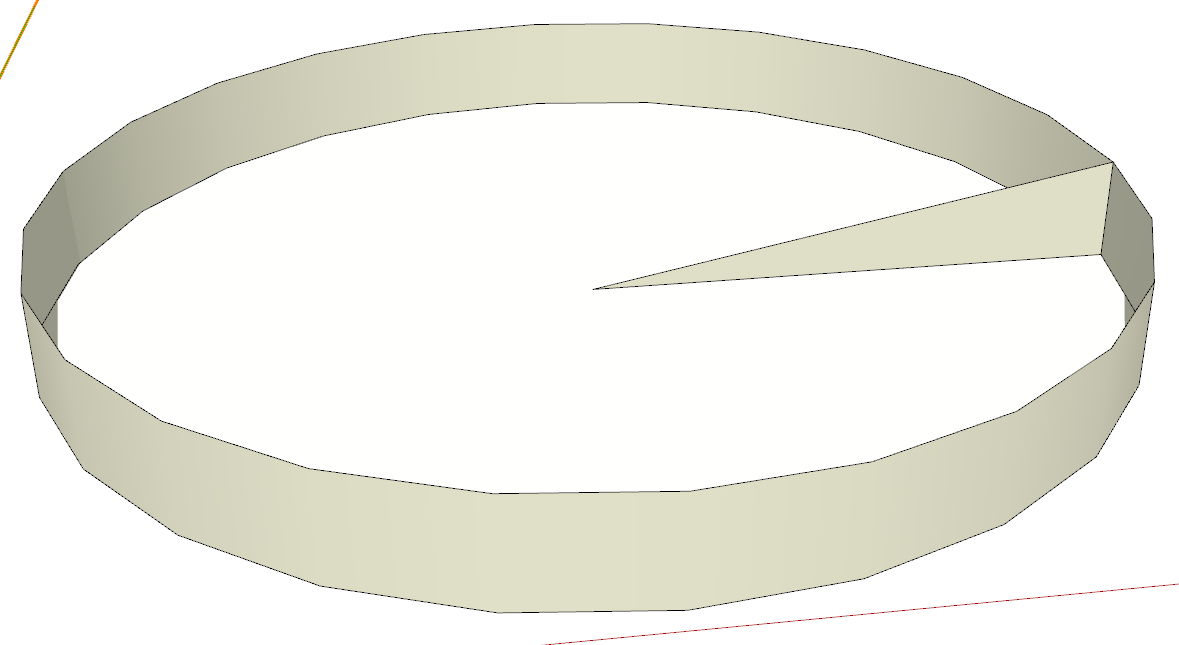
I did this test using suncalc for a location near Madrid with lat=40.4168° and the altitude at noon on Mar 21 is indeed nearly the same as $90°-40.4168°\simeq 49.83°$
So, my conclusion as a non-expert playing some detective work is that these numbers are probably provided by the local authorities according to the actual observable minimum solar altitude on the spring equinox. Because if you take the absolute minimum (-0.36° in case of Madrid, i.e. nowhere near 19 degrees as written in the table) disregarding such geographical factors; it may simply be an angle obstructed by geographical (natural/artificial) obstacles.
I hope this helps and that I am not obstructing the truth by interfering into something that is not my field of work
Hi -
This is nowhere near my field of expertise but just to point out…
You are still disregarding the requirement of 1.5 hours of radiation.
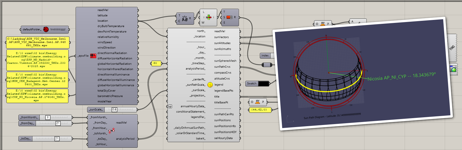
In a simple Grasshopper definition, taking the sun path on March 21st and checking the altitude of the sun 1.5 hours after sunrise gives the following numbers:
Nicosia - 18.34° Madrid - 17.06° Budapest - 15.14°
The table states
Nicosia - 23°
Madrid - 19°
Budapest - 14°
… so, obviously, there’s still something else going on.
I doubt that the determining factor here is something like artificial obstacles as that would likely limit these values to an area that is much smaller than the center of a city.
I suppose that large hills on the outskirts of a city might have an influence or perhaps there’s a minimum required level of radiation?
This…
… almosts hints that there isn’t an exact formula that can be applied and that the values are the result of a physical measurement.
-wim
thank you for your help and for opening a little bit my eyes, because I couldn’t understand what the norm meant with "Lowest sun altitude on 21March with a sunlight hour of 1,5h.
I will try to check the other capitals with your method and try to understand what it takes to get to the correct value.
Could you please show me the procedure you used to find the elevation of the sun after an1,5h, which is covered in your screen?
I used 60 for the timestep in the SunPath component and then extracted list item 89 to get the position after 90 minutes. See attached Grasshopper definition - you’ll have to insert the path to the epw files on your machine. Also attached are the epw files for Nicosia, Madrid, and Budapest that I used.
I suppose you should also check the last 1.5 hours of a day to see if that is asymmetrical…
Dear @wim, I believe you pointed me on the right path.
From what I have been able to notice, the small difference that I found is due to the system with which the azimuth angle is calculated and at what time the sunrise begins.
Since not all systems use the same calculation, in some cases the value complies with the table, in other cases I have a delta error from 1 to 4 degrees.
Since I’m “pretty sure” that the geographical data of the norm are based on the EPW weather data information, I wanted to ask, is there any way to extrapolate the above information (azimuth, sun altitude, sunrise/sunset, etc) from a EPW file?
I thank everyone for participating in this post and for your valuable opinions.
That information is not explicit in an EPW file, no. It must be calculated from the location.
A description of all variables that are stored in an EPW file can be found here:
You can retrieve the location by parsing the first line of the EPW file.
-wim
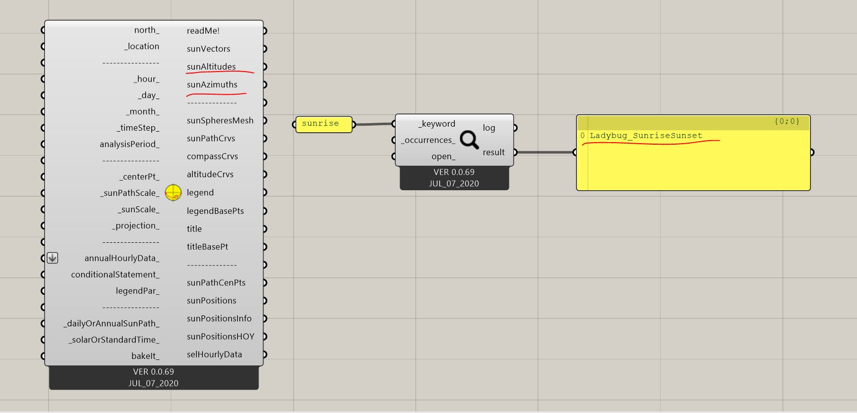
Yes. Some of that information you get from the Sunpath component. For other information, you can use Ladybug_SunriseSunset component. You can use Ladybug_Search to find if a component is already there in the library that is either using or producing the variable that you are interested in.
I asked the question to the Dutch NEN equivalent of the German DIN. They said the minimum solar altitude of 11 degrees (for Amsterdam) applies to the whole country. But how this minimum has been established they couldn’t give directly an answer. I try to ask it to a committee member of this standard…
Dear devang, I’m sorry I missed this detail.
I often use the LBSunPath component, but I asked if is possible to read those info (azimuth, altitude, etc) also from an EPW, to see if they are congruent, since for example the data of the LB_SunriseSunset component are Info taken from NOAA and not 100% congruent with the LB_SunPath.
Best regard,
Liam
Dear Jurrijn, thank you very much for your help and for the interesting answer.
Would seem strange for me if that were the case, because for example Munich, which is on the same latitude as two capitals like Vienna and Bratislava, should have 14 degrees, and not the 11 of Berlin, since they speak of data that respect localities and geographical values.
There is not such info in the EPW. But wanted to say to pay attention to the LB_Sunpath solarOrStandardTime input. It might be it is making some difference for you. I want to believe that the standard relates to solar time rather than civil time.
-A.