@Tokarzewski
Good question! I have not the faintest idea.
but with your test cases I can find an answer - and reply when I do. Thank you!
14:07:
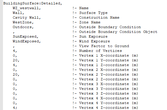
Interesting stuff. The files you provided have a very different method to identify vertices
BuildingSurface:Detailed,
    Block2:Zone1_GroundFloor_0_0_0,  !- Name
    Floor,                   !- Surface Type
    BESTEST Floor,           !- Construction Name
    Block2:Zone1,            !- Zone Name
    Ground,                  !- Outside Boundary Condition
    ,                        !- Outside Boundary Condition Object
    NoSun,                   !- Sun Exposure
    NoWind,                  !- Wind Exposure
    AutoCalculate,           !- View Factor to Ground
    4,                       !- Number of Vertices
    8,                       !- Vertex 1 X-coordinate {m}
    0,                       !- Vertex 1 Y-coordinate {m}
    0,                       !- Vertex 1 Z-coordinate {m}
    0,                       !- Vertex 2 X-coordinate {m}
    0,                       !- Vertex 2 Y-coordinate {m}
    0,                       !- Vertex 2 Z-coordinate {m}
    0,                       !- Vertex 3 X-coordinate {m}
    6,                       !- Vertex 3 Y-coordinate {m}
    0,                       !- Vertex 3 Z-coordinate {m}
    8,                       !- Vertex 4 X-coordinate {m}
    6,                       !- Vertex 4 Y-coordinate {m}
    0;                       !- Vertex 4 Z-coordinate {m}
The files I have currently use
1200.50939941406, -578.038513183594, 0, !- X,Y,Z Vertex 2 {m}
or
1200.50939941406, -578.038513183594, 0, !- X,Y,Z Vertex ==> 2 {m}
I should be able to fix this reasonably easily. The interesting thing will be trying to identify easily which files uses which format.

